 I had an opportunity to get out for a day of fishing on the Nottoway River, even Scott was able to get a kitchen pass for the day.
The weather promised a beautiful day, although the morning temperature started out in the upper 40’s. The weather forecast promised high’s in the 70’s and sunny.
Nottoway River Fishing Report – October 20, 2017
A good day to be on the water fishing.
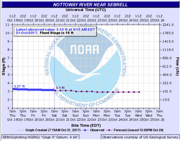
We had some recent rains, so a quick check of the river conditions was in order. The National Weather Service Hydrograph looked good.
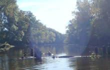
We met at the Peter’s Bridge ramp with plans to float the four-mile section from the Virginia Route 634 Bridge back down to Peter’s Bridge ramp on Virginia Route 631.
The Route 634 bridge canoe launch is a dirt path from the off road parking. My well used and much worn DeLorme Virginia Atlas and Gazetteer noted this was a hand carry launch.
Actually, we had put in here a number of times over the years.
As we unloaded the gear on the east side of the Route 634 Bridge, we saw both sides of bridge now posted with “No Trespassing” signs.
What the @#$%Q!!
Shucks!
Looking back, I guess this was inevitable. Every time we launched here, we found it littered with trash.
Maybe trash from others who used this informal drag your canoe down to the water ramp, or maybe not?
Perhaps the trash was from some random motorist — tossed from their open car window rather than properly disposing.
Anyhow, it was now posted and very much off limits.
We tried the west end of the 634 Bridge, the other side of the Nottoway River. Success, no signs, not yet anyway.
We pulled the canoe down the embankment, gently tip toeing through a nice big patch of sprawling poison ivy. It was wide open directly underneath the 634 Bridge, no debris, and no poison ivy.
But, the river bank was topped with dried mud. Under the dried mud was very much wet mud. I almost did a butt slide into the water as we loaded up the gear.
With Scott in the front of the canoe, I was able to find a good footing on a half-buried log and stumble my way into the back of the canoe.
We floated 7 hours, a slow and leisurely drift, very little paddling. There was some boat dragging through the shallow spots.
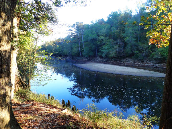
The water was low and clear, almost crystal-clear. One could easily see the river bottom in the shallow areas. This part of the river has a good amount of tannic stain.
Nottoway River Fishing Report – October 20, 2017
We both caught a lot of fish, bluegill, largemouth bass, rock bass, a catfish, and perch, — all released back to catch another day.
Scott caught a citation perch. The perch jumped from his fingers back into the water, so we never did get a good measurement. I estimated about 14 inches. A Virginia citation perch is 12 inches.
One of the rock bass I caught measured in at 12 1/4 inches. A Virginia citation rock bass is also 12 inches. This one would be my second citation rock bass here on the Nottoway.
Scott was fishing an assortment of baits, a mix of hard and soft.
I did the best when I was fishing the Zoom tiny brush hogs in the watermelon red color. I also tried fishing the Zoom tiny brush hogs in the junebug and the Berkeley 4-inch camo worm. These didn’t produce like the watermelon red brush hogs.
Yes it was a good day as we loaded up the gear at Peter’s Bridge for that drive back to the Route 634 Bridge. I was already thinking about when I might be able to get out again.